GeoBuddy 3.8

GeoBuddy uses your Internet connection to retrieve topo maps and aerial photos
Rating
Your vote:
Latest version:
3.87 See all
Developer:
Screenshots
1 / 1
Download

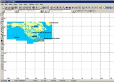
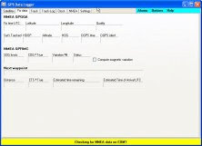
GeoBuddy is a complete geocaching solution that can display all of the geocaches in your area, as well as your own personal GPS data, over USGS topo maps, aerial photos, your own scanned paper trail and road maps. A built-in Web browser lists all of the information about each geocache, including pictures and hints left by the cache owner, and logs by recent visitors to the geocache.

Comments

User

Your vote:

Related software

GPS TrackMaker
GPS TrackMaker
Free
rating

It is the most complete free program for GPS devices.

BleuPage
BleuPage
rating

You can promote products and build marketing lists inside Facebook newsfeed.

GEO Spider
GEO Spider
rating

It can analyze and trace all network applications on the fly

GPS Data Logger
GPS Data Logger
Free
rating

Is a free software for recording, monitoring and plotting GPS data.

MahJGar Buddy - Pogo
MahJGar Buddy
rating

Automatically plays for you, or shows you hints about Pogo's Mah Jong Garden.